-
-
Par Across the land le 12 Août 2013 à 09:46
Wednesday July 18 :
 And now the day of departure has arrived! In Paris for two days, I finished my final preparations. The hardest part was to make a list of food as it needs to be light, less bulky and nutritious. In the end I opted for meals based shuffleboard Breton, bars and snickers and baby milk - is there more calories!
 So I start with a 15kg backpack in baggage (including 8.5 kg of food - food imports is limited to 3kg but it is better to pay a fee at the airport buy everything in Iceland (it s not cheap there!) I take the rest of my stuff in hand luggage.
The departure is from Paris Orly airport at 22:45 and the arrival is at 0:10 arrival at Keflavik (Iceland is the time zone of England). I plan to stay overnight at the airport if possible or go camping at Keflavik.
I will spend my first day in Reykjavik. I intend to send a parcel of food in the refuge called Dreki near Askja to have a lighter backpack.
Thursday July 19 :
After a very short night in Keflavik airport, I take the bus to Reykjavik. City buses are yellow and marked with a yellow S in a red circle for "Straet ó" . I take the bus No. 14 to the campground. Problem it costs 350 ISK. I have 1000 ISK and the driver does not change! A woman spontaneously offered me a ticket! I am unfortunately unable to transcribe the name of this passanger. She notes on a piece of paper the name of the stop at the campsite ... First impressions are positive Icelanders are friendly! After I pitched up my tent I slept and then I went to a supermarket. This is an opportunity to walk and discover the area around the campsite. Iwill leave tomorrow for Akureyri in northern Iceland. 
Friday July 20 :
After the first rainy night, I went by bus to the north. The trip takes me 6 hours with some breaks. I saw many fjords, mountains, rivers. The landscape reminds me Scotland. In Akureyri I learned that the only way to send a refuge to Dreki is to go to Myvatn ... so I have to reconsider my project : walk from Myvatn with a lightweight backpack or from Asbyrgi with a heaviest backpack. Here is my dilemma!
I spent the rest of the day in Akureyri with a couple of Swiss German, Micha and Sabrina arrived in Iceland one year ago. Micha showed me the waterfall : Goðafoss of the Skjálfandafljót river. It is 12 meters high and 30 meters wide. Its name means "fall of the gods" because during the transition to Christianity icons of ancient gods were thrown here. We took some pictures. He did a timelapse. We talked about the culture and the Icelandic pronunciation. Then I completed the blog on a qwertzy keyboard...

link : Galerie Flickr de Micha
Prononciation of Icelandic :
Some words in Icelandic :
góðan daginn = hello
takk fyrir = thank you
bless = good bye
Saturday July 21:
Direction the pretty little town of Husavik. This harbour city is known to be the ideal place for whale watching. They come to feed each summer in this area. Several species of whale can be seen like the minke whale, humpback and pilot whales. Between sea and colorful fishing boats, I feel like at home. The sky is gray and the sea is lead. There are colorful wooden houses and a wood church (1907).
Sunday July 22 :
I go to Asbirgy starting point of my north-south long hike. I did not send parcels. With the bag loaded with 20kg I am committed towards the canyon horseshoe Asbyrgi. I started by a wrong path which leads me to observe the canyon from a hill. Go back. Too excited to begin the march to the south, I follow a 4 wheels road that leads to Vesturdalur instead of following the path through the canyon. I walk through a forest of stunted birch, but as Icelandics say "On ÞÛ ert glataður í skóginum íslensku Statt" "If you're lost in an Icelandic forest, stand up!". A little rain falls a few moments but it is quickly replaced by the sun. For nearly two months it did not rain in Iceland. Weather seems more stable now than before. The consequences of global warming? A bird with a long beak followed me all the day pushing a warning "i" . It seems to be a sandpiper . The bag is heavy on my shoulders and it was with pleasure that after twenty kilometers I finally stopped in Vesturdalur. I pitched up my tent. I went then in this lovely place between volcanic rocks, lichens, ferns and flowers ... Take your time is a great way to travel. For sure, I already knew I will not do a speed record but this is not my goal! 
Monday July 23 :
It's raining steadily. I couldn't see anything. What to do? Leave without seeing the beauty of the area or wait and hope that the weather will change. In my opinion the true nomadic traveler is one who takes the time to see, to experience. Have the time to wait is a privilege, a luxe that many tourists have not. I have time, I'm waiting! The wind rises slowly with the hope that the rain goes away. I decided to walk a little bit in the northern part of Vesturdalur leaving my stuff in my tent. The place is amazing. The volcanic basalt formations arise taking rectangular shapes. The frame is green. I climbed the peaks of ancient volcanoes before returning to my campsite. A couple of Austrians settled in the neighboring tent invited me to drink tea and enjoy delicious cinnamon biscuits. The sky is low, it's cold. I try a start late at the end of the day but I quickly went bac. The rain redoubled intensity. I will stay one more night in Vesturdalur.
Tuesday July 24 :
The rain is still falling, but with less intensity. I decided to continue my journey to the south. I walked along a gorge. The vegetation is sometimes shaves sometimes higher. Small silver birch trees appear here and there. The rain stops. I then descends into the canyon where I passed my first river. Pretty small waterfalls succeed. I returned again on the ridge. The wind blows. Vegetation gives way to a dry space made of black pebbles and sandy soil. The river I see is the J ökulsá á Fjöllum "River Mountains" born of melting glacier Vatnajökull. This is one of the longest rivers in Iceland (206km). I walk after that with many up and down. I follow the path along the river where I'm enjoying the spectacle of a powerful waterfall creating a rain cloud. After crossing a marshy area, I crossed a scree slope. I have to climb a steep slope then. The slope is steeper : a rope was placed on this route. I attach my walking sticks in my bag and I firmly seized the rope. Let's go ! Please do not slip, do not fall! With the weight of the backpack climbing is not easy but I finally reach the top. Later the black sand dunes appears. Some grasses grow here and there. Their dance with the wind draws a perfect circle. After two kilometers, a rumbling is heard. Gallons of water rushing abruptly from forty meters. This is the waterfall Dettifoss, the most powerful in Europe, with a rate of 200 m 3 per second. I pitch my tent in the bivouac area. Two jerry cans of water are available. Here I met a Belgian couple Delphine and Arnaud. They will be my companions to Myvatn.
Wednesday July 25 :
The night was particularly cold. At 8am we head towards Lake Eilifsvötn by off-track bumps covered with short vegetation. We no longer walked but jumped from bump to bump. The increase is not easy fortunately. Some rocky flat areas are intercalated here and there. We crossed some fences. Finally we reach the lake Eilifsvötn n the southwest. We went along to a black sand cove where we decided to camp. Arnaud had with him a fishing line and fish trouts ("bleikja" in Icelandic). Delphine and I picked up some dry azalea roots to make a small fire. No trees grow in this place. The fire will be short-lived. Suddenly a shout. Arnaud caught a trout. He released because it was too small. Just a few minutes after he caught another trout. This time the trout is a good size to be kept. Arnaud caught ten trouts. Delphine managed to catch one but the fish escaped. Nothing for me! ... We kept three of the ten. This was our dinner! With dry ham and soup, we ate the fishes. Yummy! What a beautiful day! 
Thursday July 26 :
Walking through the bumps left some traces: we had some blisters! We continued to reach Lake Myvatn and Krafla. We reached rocky and sandy areas. Walking without following the trail is particularly exciting to think that we are in a place where nobody came before. We continue leaving the lava flow of 1984 on our right. Arrived at Krafla, we climbed the Krafla Viti. This is a firework of colors : yellow, blue, red, white ... A smell of sulfur arised. The interior of the crater is filled with a turquoise water. The place is surreal. Delphine and Arnaud decided to go to Reykjahlid close to Lake Myvatn by bus. I decided to continue by feet. I started by walking on a lava field still smoking in places. This is the úkur Leirhnj. This area is potentially dangerous because very active. It is recommended not to leave the marked trails. I'm walking the trail through a black immensity. Cooled lava takes many forms: twisted plates, rough rocks. The backpack is heavier and heavier. My legs were heavy too and my feet painfull. The sky became dark. I climbed to a hill and then went down by a long descent. Nearly 3 hours after leaving Delphine and Arnaud I finally reached the campsite of Myvatn. I'm exhausted and I arrived too late to refuel at the supermarket. Arnaud and Delphine welcomed me by sharing chips, apple juice and peanuts.
Friday July 27 :
Today is a rest day! I completed the first part of my North-South crossing. My feet have suffered and a few blisters appeared. It's nice and warm but I doubt. Weight of the bag, painful feet, long distances between shelters ... I wonder if I can continue by feet. This project is important to me but the travel is not a performance ... What to do? Continue or stop. I decided to go for a small walk to change my mind. When I returned to the campsite, I found Delphine and Arnaud. Sitting by the lake, we ate. For this last night together, we decided to go for a drink in an Icelandic pub. Icelanders are accustomed to go bar on Friday night. It's Friday and the pub was full. We taste the local beers. The Gamli is our favorite. It is amazing to know that beer was banned in Iceland until 1989. To circumvent the law, bars offered the non-alcoholic beer (Pilsner) mixed with vodka. We tested the traditional Icelandic alcohol: the Brennivin. There is a strong alcohol potatoes flavored with caraway. This beer is called "Svarti ði dau" (Black Death). We finished the evening by speaking at the campsite. To meet Delphine and Arnaud was really nice!Voyage sur la planète Islande by Delphine et Arnaud
Saturday July 28 :
After a night of reflection, my decision was to keep walking! I took 3L of water with me because it was very warm and there are very few water in the lava fields. Strangely the bag does not seem so heavy. I start to follow the edge of Lake Myvatn accompanied by a swarm of gnats. Their presence irritates me quickly and I used the headnet. Lake Myvatn is an ideal place for birds. There are many different ducks. Arrival at South Lake, I followed a path and I reached a lava flow. It was very sunny. The soil was dry. I feel walking in a hot desert. Close to the Sellandjafjall mountain, I saw that the first stream shown on my map was dry. I was thinking I could not go further. But I saw two hikers and after few minutes two hikers more. Baron (Thomas) Riquette (Enrique), GAEG (Gaetan) and Carter (Adrien) are French and like me they want to cross from north to south Iceland. They left Myvatn. We camped together at the bottom of Sendjafall. Like me, they were looking for some water. Carter found a river 900m away and filled all the bottles. During the dinner they offered me a piece of cheese, a few apricots and tea accompanied by brandy apple!
Sunday July 29 :
While the team of four climbed the Sellandjafjall, I followed my own path, skirting an area of tundra. I discovered a stream where I filled my water bottles quickly. The landscape becomes increasingly arid. Vegetation gives way to a lava field in which Iwalked. I decided not to follow the trail who makes a wide detour to reach the refuge Botni. I took a short cut across the field. Compass and the GPS does not indicate north in the same direction. There is a difference of 20 ° west between magnetic north and true north. This is called magnetic declination. Compass is unreliable because it is disturbed by the magnetic forces from the ground. So I navigated with GPS through the dunes of black sand and pieces of lava. Progress was slow and long. I could only see the refuge Botni in the last two hundred meters. Two people were busy there. They were preparing the hut for a dozen people. I pitched my tent nearby. There is a small lake. I went to soak my feet and did a summary toilet. At dinner, I found the four french guys. Icelandic hikers did a barbecue. They invited us to share their meal : roasted lamb meat, pork, vegetables and Italian red wine! Welcome to Iceland!
Monday July 30 :
I started to walk through a lava field. Welcome to the "black hell!" I was guided by black cairns in pile of black rocks on a black sand floor. Not easy to navigate! The traces left by 4x4s were very useful. The sun shone. It was hot. My feet were painful from the walk. I had several blisters but I was still walking without any stop. After several hours, I finally left the lava fields to reach a vast desert of black sand framed by mountains. Two kilometers before arriving at the Dyngufjell hut I saw the four uys coming down from a mountain. We met at the shelter where there is a small stream (which apparently can be dry quickly depending on the time of day but today it was not). The hut was empty and the booking list indicated no group for that day. What a deal! So here we were settled in this very comfortable hut. I took a bath in the stream. The water was warm and it was nice. A German couple gave to GAEG dried food. We shared it. These additional food were welcome! We spent the evening to play cards (we play the "Corsican battle" mixture of Uno and Jungle speed).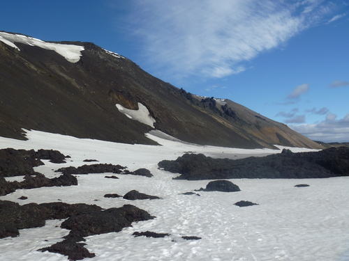
Tuesday July 31 :
Last day of the month and a day that promises to be great! I alternated climbs and descents to reach a first snowy slope. It was a real pleasure to walk on the snowfields. After several hours of climbing, I reached the ridge of Dyngjufjöll (mountains of the Askja caldera). Then I went down by a snowy slope. I was skiing. I went around the caldera. Walking on the snow changed from walking on stones! I discovered the Viti lake. The bottom of the caldera is covered by a vast lava field. In its eastern part there is a wide dark blue lake : Öskjuvatn. After crossing the lava field with no markup, I finally won the crater Viti. It is a maar ( volcanic explosion crater). It is filled with a sulfurous turquoise water. It is a "hot pot", a hot spot. The smell of sulfur is released. I went down by the steep slope to the crater. I took a bath. The water was not so hot (28 ° C). The smell of sulfur was strong and my swimsuit and my Brazilian bracelet smelled a long time after! Then I kept walking in the direction of Dreki. The caldera is active : fumaroles can be seen in different places. I left by climbing a very steep slope. The view from the top was beautiful!Then I began a long descent that seemed endless. It was 7:30 p.m. when I finally arrived at the hut after 8:30 Dreki of walking. What a fantastic day! 
Wednesday August 1 :
I left Dreki and reached a vast desert of black sand at the north of the largest glacier in Iceland: Vatnajökull So I walked in the sand in the sand and then finally in the sand.. Some 4x4 passed, releasing clouds of sand. One of them stopped and asked me if everything was well. He warned me that the glacial rivers are shallow but could be very strong in the late afternoon. It was 11am and I was still far from the flood zone. I decided to walk without stopping and caught the four french guys during their one-hour break. We started together but I was quickly distanced. I continued to walk alone as usual. The wind blew in some places creating tornadoes of sand. I dreaded the quicksand. No way to cross the vast expanse of glacial rivers today. With the guys we have decided to choose the same bivouac area away from the flood zone. I crossed a short glacial river and found them on the other side. The water of the glacial river grew rapidly at the end of the day. We pitched our tents in the sand with stones collected on the slopes. The wind blew stronger. Sand came under the tent. There is sand everywhere on my hands in my hair, on my gear ... In the middle of the night the wind finally stopped and I finally fall asleep ... full of sand.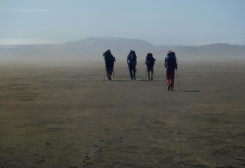
Thursday August 2 :
In the morning my tent was unrecognizable : originally green it became dark brown! I tried to remove sand without much success. It sticked to everything. The four guys strated before me in the direction of Kistufell. I walked in the bed of glacial rivers dried up in the morning. I joined a little later Baron Riquette, GAEG and Carter. They stopped to melt the ice. I did the same and they left at this moment. Once my two water bottles filled with a mixture of water and ice, I kept walking. Glacial rivers were not yet appeared when I reached a lava flow. I climbed a slope of rocks. I found a 4 wheel track leading to the shelter. I passed near Mount Kistufell. At 14:30 I finally arrived to the Kistufell hut. The french team was here two hours ago and were ready to leave! They had to go in two or three days to Nýidalur hut where their second food parcels was. I was exhausted. The bad last night did not allow me to recover from the long day of walking of yesterday. I finally decided not to follow them and staid at the shelter. I will never meet again the french team but I do not doubt they have finished crossing to Skogar. I was alone in the emergency shelter. I started reading the guestbooks and found messages from Olivier Site like hike when he crossed through East-West, from the American Andrew Skurka and from Jerome Jauffres who crossed from North to South in eleven days! I wrote too. The shelter was clean and comfortable. My right foot was slightly swollen, I discovered a new blister ... it does not tell me anything good, but I'll see what will happen the next day. I opened the cupboards, boxes ... and finally found a bag of thyme "The three marmots " and a package of baby wipes. I did a cleaning of my feet and used it to remove the layer of sand covering my face, my hands ... 
Friday August 3 :
Sunrise at 6:40. My foot was less swollen! I started to melt some ice and refilled my water bottles. I took my time this morning. I left the hut at 9am. The day began with alternance between lava field and sandy areas. The wind was now forming sand tornadoes. I crossed first ford with neoprene socks and plastic sandals. Then I continued with a larger ford. The hours passed and glacial rivers grew quickly. To go faster I decided to cross barefoot. What a bad idea! It was so COLD! My feet were frozen! The neoprene socks were not a luxury! New ford and this time I did not hesitate: I put the neoprene socks. Water loaded with volcanic sand, I sometimes mid-calf in places and I crossed without problem. The rest of the route is more rocky. A new small stream : I decided to go over. I trun and jump with the walking sticks and .... ZAP! Reception with the backpack was catastrophic: I fall along the other side! Fortunately nothing broken, just a few scratches on my hand and left knee. I met rangers of the Vatnajökull National Park. I asked them about the possibilities to cross rivers to go to Vonarskard and if it is possible to buy food to Nýidalur. They advised me to take a detour to go to a bridge because the rivers are important and strong current. About resupply, they responded negatively to me and offered me bread to allow me to go further. I had still something to eat but I was getting hungry - the quantities consumed were not enough important. After several days in the "Black Hell" I found moss and water. The rest of the day was a long walk to reach the bridge following a 4x4 track among the stones. I decided to pitch my tent near the bridge in an area relatively sheltered from the wind. Tonight my foot was not swollen all was fine! 
Saturday August 4 :
Heading south towards the Vonarskard. After a mile, I discovered a beautiful waterfall. I decided to go off-track guiding me with map and compass. The ground covered with a mosaic of pebbles is loose. It was nice to move on this ground. Region Vonarskard is splendid. The mountains with some snow fields have colors ranging from yellow, green and brown. I had to cross many fords sometimes every few hundred meters. Take off the boots , then put them again and take off again.. became annoying especially since it was sometimes difficult to see if there was still a ford or not to cross a little further. I saw a dozen migratory geese . I pitched my tent on moss near a small stream. The smell of sulfur was released and the mountainsides had colors ranging from red to yellow. I saw some fumaroles near Mount Eggia. Alone in the middle of nowhere, I happily watched the landscape! 
Sunday August 5 :
The sun shone. Streams were not appeared yet when I left this heavenly place. I crossed some fords. The first fords were not too cold, however the last one was. A 4x4 stopped suddenly ... and it was the couple I met before Kistufell who had warned me about the glacial rivers! We exchanged a few words and then I resumed my journey to slow walking pace. I left behind me the Vatnajökull National Park to explore a vast lake with turquoise water the Hagongulon. The south end of this lake is surrounded by an impressive mountain. A 4x4 rangers who go to the Vatnajökul park stopped and asked me some questions (how I am, where I go, if I met other hikers ...) They told me that Versalir hut is closed. Since morning, I walked with my short and I end up having a good sunburn on my legs! Who said that the weather is bad in Iceland! Arrival at the south end of the lake, the wind was strong but I managed to pitch my tent as well as possible in a sheltered place. The soil was stony and I had to remove all the stones to clear the area and be able to sleep... on the sand! It was 21h when I went to bed. The tent was moving with the strong wind.
Monday August 6 :
Wake up at 6.40am as usual. I passed near a water reservoir and used it to fill my water bottles of water. I sank a littlebit in the sand but nothing dramatic. I walked on the 4x4 road that joins the F26 road connecting the north to the south of Iceland through the Sprengisandur desert . The road is somewhat curvy, so I decided to draw my own road in a straight line. The F26 was very busy. For several days I had only met one or two jeeps. I started to count the cars. I saw 27 jeeps, three buses and a cyclist with whom I exchanged a few words. I crossed a river where the water was very clear and sit on the bank for a short break. I helped a driver to cross the ford by showing him where he could go. I kept walking towards Versalir but leaving the F26 for a more direct path. For several days I walked with the obsession to eat. Started with 15 days of food it was my 16th day! The wind was very strong. When I arrived at Versalir, I discovered a stable and two closed buildings. While I was in my tent, three cyclists arrived. Arnaud, Pascal and Nicolas are Belgians. They hoped to find a hut ... Arnaud was very friendly.He was here for two months before returning to America where he undertook the project of crossing the American continent by bike and climbing the highest peaks . This is a sacred traveler! I expressed my meager provisions and he quickly offered me a chocolate bar and a packet of Maryland cookies. I thank him very much!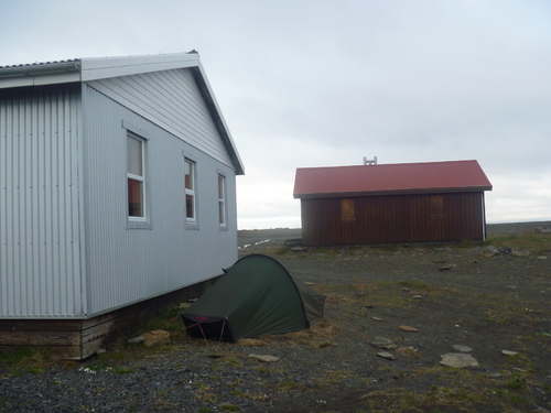
Tuesday August 7 :
After a very good night on straw bedding, I had to deal with a strong and cold wind. The sun was hidden by thick gray clouds. I put my hood, hat, fleece gloves, mittens-on, windbreaker jacket. Today's route did not offer something interesting to see. The landscape consists of rocky hills interspersed with rivers lined with moss. The weather was not good : it started to rain. Walking on the F26 was long and monotonous.. 4x4 raised clouds of dust. After a break near a river I decided to leave the road going off track. This is better! The roadwas marked with poles on the last eight kilometers. The day ended by crossing a ford, climbed a hill and finally arriving above the Porisvatn lakewhere I decided to camp. This day I counted 30 jeeps ... the F26 is a highway! Wednesday August 8 :
It rained all the night. In the morning it's still raining. The visibility is very low. I have only one big day of walking to reach Landmannalaugar (resupply place) ... walking off track in these conditions is not obvious because it is not possible to anticipate possible rivers, wetlands .. . I wait in the tent hoping that the weather become better. Around 10:20am I prepare my backpack but it starts still to rain. It's difficult to see with the poor visibility and the strong wind. Losing altitude, I leave the fog and rain. F26 ends in asphalt road. I discovered a hydroelectric building. High-voltage lines arise on the landscape.I am back to civilization! I keep a more chaotic 4x4 road and reach another hydroelectric bulding. A 4x4 truck stops ... and it was amazing to see the people I met in Kistufell and near Hagongulon. We talk a while. Andy and Anny are German. It's the 12th time they come in Iceland! I explain my project and my eagerness to reach Landmannalaugar. They offer me a salami, black bread with a strange taste and a rum-raisin chocolate bar. In this gloomy weather this generosity warms my heart! After the F26 I walk on the F208. I'm overtaken by many 4x4. My legs become painful. I have not drink enough today. I keep my water because I have only one liter of water and there is no water in the lava field. I pass close to the Tungnaá river which carries an impressive amount of sediment. The water is turbid and undrinkable. The road winds and I finally take a short cut through lava fields. The weather is cloudy. At 8:30pm I have still 4km to walk to go to Landmannalaugar. I am near Lake Frostastadavatn. The area is flat with moss and protected from the wind. The location is ideal, so I decided to stop and to camp there. After filling the water bottles, I enjoy salami and black bread offered to me. At 11pm it is dark and it is no longer possible to read without headlamp like in July.
Thursday August 9 :
A thick coat clouds covered mountains, a little rain falls. A rainbow sky emerges on the other side of the lake. The rain stopped but the weather is threatening. I decide to go to Landmannalaugar via Ljotipottur: a crater with red and black cliffs filled with a deep blue lake. Magnificent! I walk by a nice track to Landmannalaugar. There are many people! I rush to the Mountain Mall. It is a bus parked in the summer where you can buy groceries. I eat a sandwich! Ymmy! I was hungry! I pitch my tent between several other ... I go for a walk. The weather becomes better during the afternoon. What a beautiful place! At the bottom of the rainbow mountains few sheeps are grazing ... Without my bag, I can go fast, I run on the tracks. Back to the campsite, I build a clothe line with a cord and a walking stick. A leader of a small group of young French in holiday in Iceland for two weeks gives me generously a smocked trout. I really enjoy it!
Friday august 10 :
Too many people, too much noise ... difficult to sleep in these conditions ... these are the joys of camping! So it was with eagerness that I leave this place to start hiking the famous hike Landmannalaugar to Porsmork called "Laugarvegurinn" (hot springs road). I walk on the mountains of rainbow rhyolite punctuated by columns of steam and sulfur deposits. Splendid! Difficult to find the words to express what I feel. I quickly reach the Hrafntinnusker hut at 1129m altitude. Low clouds hide the mountains. In this area with lots of wind there is no vegetation. The ground is covered of rocks. I decide to stop here after only a dozen of kilometers. I want to take my time and not to rush to finish this long journey in direction of the south. I pitch my tent protected from the wind by black obsidian stones. But how fast does the wind blow? I have no idea ... I just hope that the tent will not blow away.
Saturday August 11 :
The night was particularly cold accentuated by the wind rushing into the tent. I tried to sleep the most of possible ... In the morning the wind is less strong I leave Hrafntinnusker with many other hikers. Finished landscapes traversed without a soul. I leave the multicolored hills to a green valley where sheeps are grazing. I reach Alftavatn and camp there. I have all the afternoon and I decide to try to fish. I build a fishing line with a fishing rope found close to the lake Eilifsvötn, a safety pin and a walking stick. I spend a long time to untangle the rope. My first test is simply catastrophic! It lacks a weight. I clipped a stone and finally after three to four shots the stone leave. No trout for the dinner! The wind begin to blow more and more. There is no protection here. The tent inflates and deflates with the waltz of the wind. .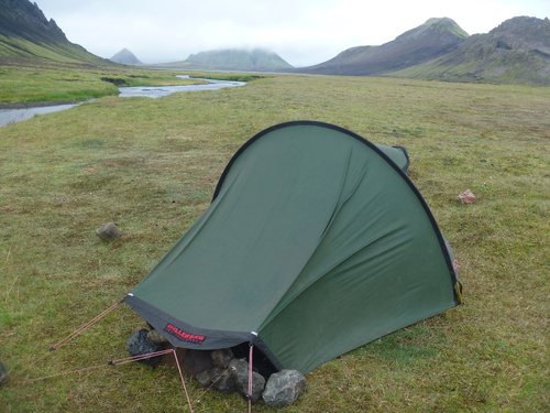
Sunday August 12 :
Stormy night. A tent blew away. In the morning the rain is added to the wind who continues to blow forcefully. I walk against the elements. The wind destabilizes me sometimes. I cross a ford and a second passling many hikers. Then I am alone ... The rain finally stops. I walk easely the 15km. The landscape is largely hidden by the clouds. I hesitate to continue but I prefer to stop at Ermstur hut hoping that the next day will allow me to enjoy the scenery. So I camp near a river sheltered from the wind. The soles of my shoes have lost their grip and it happened to me several times to slide downhill in the past few days. So I try to make some cuts with a knife to give them a bit of grip. Hour after hour hikers arrive . The tents are pitched close to each other ... Monday August 13 :
The night is quiet. A tiny drizzle falls. After the stones of Ermstur a low vegetation appear becoming lush when I lose altitude. The earth is acid. The vegetation consists of azaleas, small crawling trees and moss. It is the toundra. I see two people on a hill. They try to go down from a hill by a cliff. I keep walking but suddenly I heard a noise. I understand that a rock fell and someone fell. I rush in this direction. The guyhas just few scratches to the elbow and knee. He slipped and fell hitting a stone in the chest. "I was stupid!" he told me! All is fine so I keep walking and passes over the Ljosa "river of light" rushing into a crack of 2 meters wide. A wide ford appears. Two others people are preparing to cross. They look at me, I look at them. Who will dare to start first? They do not seem sure. I look the river banks in search of convex areas where the water is stirred. This is the place where there are large deposits of sediment and rocks making the river shallow. So I start the first and cross the ford easily with water knee deep. The others start to follow me. While we have crossed a group of hikers arrive on the other side. One of them starts quickly by choosing a different area of the mine: shorter with straight edges. They cross with lots of water and stronger current! Everybody follows him without trying to go through another place. Some just avoid a bath! So it's best to observe and apply knowledge rather than rushing. I go through a forest of birch trees. What a pleasure to find myself in this ocean of greenery after so many days of walking in the gravel and sand! The flowers bring a pleasant smell and I breathe with happiness. The hut at Porsmork is Langidalur. It is near the river Krossa. I pitch my tent in front of Eyjafjallajökull. Two polar foxes tamed by the warden are playing in the grass. They are dark brown and not much bigger than a cat. I bought some provisions for an exorbitant price (4 times more than the price in France) but I am terribly HUNGRY! The food purchased Landmannalaugar were not enough ...
Tuesday August 14:
Last day of the North-South crossing, I'll walk from Porsmork to Skogar via the pass of Fimmvörðuháls. To start I must cross the wide river Krossa with impressive speed. The bridge shown on the card is not installed . It is in a sleigh pulled by a tractor that I cross finally. I climb then by some tricky parts (pass on a ridge with a vacuum on each side, crossing areas with ropes and chains). The wind is strong so it is hard to walk! The scenery is magnificent! I discover lava of the volcano Eyjafjall that blocked all the European airspace in March-April 2010. The contrast between the deep black lava and the ice of Eyjafjallajökull and Myrdalsjökull is beautiful. I cross the lava field and some snow slopes before taking a break in an emergency shelter. I meet there two French Igor and Tomas Peter who are doing a north-south crossing from Myvatn via Nýidalur. They read my messages in the hut books of Dyngufjell and Kistufell. It's fun to meet them on the last day of the long hike! I continue my descent to Skogar along a succession of waterfalls all more beautiful than the others. I see far the sea, the Atlantic Ocean. It is with great emotion that I finally arrive at the bottom of the Skogafoss. Well, it's done! After 24 days of walking from north to south, the Greenland Sea and the Atlantic Ocean are connected! I found Igor and Pierre Tomas at the campsite where we celebrate the end of our hike by tasting Icelandic delicious hamburgers and talking until late in the evening.Wednesday August 15:
By hitchhiking, I go to Vik (Vik i Myrdal) small town famous for its long stretch of black sand beaten by the waves of the Atlantic and haunted by the incessant howling of the wind. Along the beach stands the imposing cliffs of Mount Reynisfjall. This is an important breeding area for seabirds including puffins "Monday" in Icelandic. Columns of lava emerging from the sea are Reynisdrangar that would according to Icelandic folklore trolls turned to stone by the daylight. I pitch my tent iclose to the cliff and the beach. I go to watch hundreds of birds flying in the sky and go close to a Monday. This bird with a colorful beak like a penguin jumps from the cliff to the sea to catch small fishes. Its short wings and webbed feet allow it to be as comfortable in the air and underwater. He spends most of the time on the high seas except during nesting. Iceland is the ideal breeding ground for puffins. 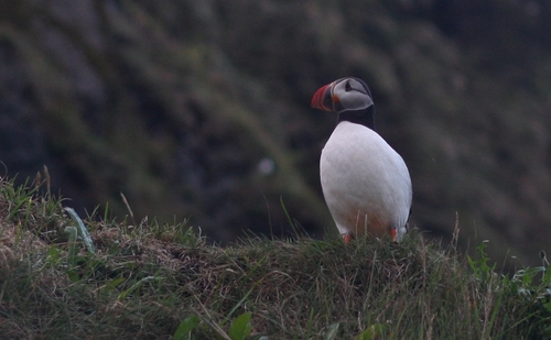
Thursday August 16 - Friday August 17 :
I go next to Skaftafell. I walk along the lagoon of the Skaftafelljökull glacier where blocks of ice float. A small marked trail leads me to Svartifoss a waterfall surrounded by formationsof basalt very surprising to see. Then I find charming houses roof covered with grass. This is the traditional Icelandic habitat. The interior is all made wood. unfortunately I could not sleep inside! I still sleep at Skaftafell campsite in order to realize a day hike around the Skaftafellsheidi. The next day I admire the glacier Skaftafelljökull from a hill. The sky is overcast but some rays appear through the clouds giving a special atmosphere. The sky becomes increasingly threatening and the wind begins to blow stronger forcing me to skip the climb of Kristnartindar. Back to the campsite, I take my tent and go to try to hitch hike to Jokulsarlon. Unfortunately it is the end of the afternoon and cars go in the opposite direction. I progress only of 6 short miles on the main road which goes around Iceland. Arrival near Swinefell, looking for a campsite indicated on my map...but I can't find it. A car stops and the driver tells me iwhere is the campsite and offer me a ride., Brighid, Scottish geologist, works 2km away at the bottom of the glacier Virkisjökull. She agrees to show me her work the next day.
Saturday August 18 - Sunday August 19:
In the morning, I head to the glacier Virkisjökull where Brighid works. She conducts theoretical research for the British Geological Survey on the evolution of the glacier and glacial rivers in particular. By pumping water from wells drilled in the moraine of the glacier, she calculates the rate of filling of underground rivers, analysis, temperature, pH and the source of water (rain or snowmelt). I watch a new drilling. It's really interesting! Then I go on the Highway No. 1 to hitchhike to Jokulsarlon. This place is magical! It is a glacial lagoon where the Vatnajokull just break up into bluish icebergs. These icebergs float in opaline water sometimes five years before finding the way to the sea and sometimes fall on the black sand beach. I pitch my tent in this surreal place. Two seals are just playing in the water in front of me. A great skua flies. The rain began to fall. On the morning of August 19, the lake is calm, the icebergs are reflected in a water mirror. The tourist buses are not there yet and I enjoy this moment. I am impressed by the beauty of the ice blocks with many different blue. The blue iceberg is due to the absorption of all wavelengths except the one corresponding to the blue light. This blue light is more or less returned and so gives more or less intense blue.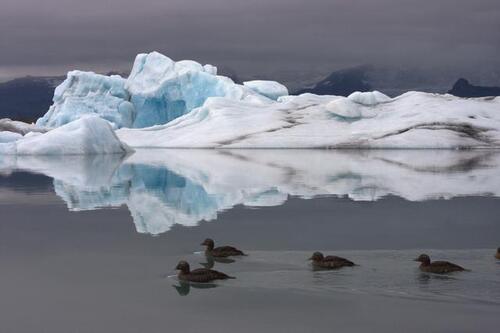
Sunday August 19 - Monday August 20 :
I leave Jökulsarlon in the afternoon of August 19 in the jeep of Andre. Andre is German and he drive around Iceland with his jeep to make a film.He is equipped with several cameras, a rail to make timelapses ... He has already made a long travel across Europe to Asia with a jeep and a ski pulk treck in Norway. Once again this is a rich and beautiful meeting! He stops me to the town of Höfn which means harbor in Icelandic. This port city is as the European capital of "Humar" lobster. In this Monday August 20th, 2012, I have a special thought for my maternal grandfather who celebrates his 98th birthday! This is the day of my birthday too. The spectacle of Jökulsarlon was for me a wonderful gift. I enjoyed a "Vinarterta" Icelandic cake made of sponge sandwiched between the rhubarb jam. I really enjoy it! It's cloudy today. I go to the port following a path close to the sea. The sky is dark and from time to time sun shines. The landscape is more beautiful! Many birds nest at the peninsula of Höfn. I'm attacked by an Arctic tern . Fortunately for me, the nesting period is finished ... Höfn is an important fishing port. This is the major activity of the city. Back in my tent, the heavy rain begin to fall ... I spend the rest of the day in my tent to enjoy ... "Kleinur" Icelandic donuts.
Tuesday August 21 - Wednesday August 22 :
It rained all the night. I try to hitchhike. Three French tourists Lucia, Amelie and Yann give me a ride. Mountains and glaciers are hidden by the clouds. We stop at Jokulsarlon in the rain. Icebergs are wrapped in a fog that gives a spooky atmosphere. This place is a feast for the eyes whatever the weather is! We go back ont he road and enjoy some sunshine to take a break in Haalda. They give me an Icelandic beer "Viking" and the "Hverabraud" bread of Myvatn and I share with them some Norwegian Arctic caviar. They drop me near Skaftafell. I have a new ride with a couple of French to Kirkjubaejarklaustur. I buy "flatkökur" (rye pancakes), the "hardfiskur" (dried cod) and the "Egils Appelsin" (similar to the Icelandic soda fanta) The next day, I walk around Kirkjubaejarklaustur. Systrafoss a beautiful waterfall with two falls is on the west part of the village of 120 inhabitants. I climb the path to the top of the cliff and discover a vast lake, Systravatn, where the nuns of the Convent of Kirkjubaejarklaustur came to take a bath. A swan advance along the shore. I try to get closer but within seconds the lake is ihidden by the fog ending my walk. I try to hitchhike during 1:30 ... surrounded by a swarm of gnats! I go to the gas station nearby and order a "Pylsur" (hot dog) "ein med Ollu" (with everything: fried onions, ketchup, remoulade sauce). Icelanders are very fond of this kind of food (by example fast food burgers). My hot dog swallowed, I regain my place. Barely a minute later, a car stops and drive me to Vik. On board an Israeli couple. I asked about their country. At Vik, I leave after few minutes in the direction of Selfoss with an Icelander. We speak about Iceland and the Icelandic culture ...
Thursday August 23 :
I enjoyed the "skonsur" pancake-like blinis. It rains and I decided to take the bus to Geysir. Geysir gave birth to the word geyser. It is a geothermal area. Geysir is a geyser that by the past threw a column of water 80 meters high. Today it is no longer active but another geyser "Strokkur" threw about every 6 minutes in a water column of 15 to 30m high. The show is amazing. A German named Tarek give me a ride to the high double-32m waterfall Gullfoss. There is a rainbow at the bottom. Tarek brings me back to Geysir and offers me two bottles : one liter of water and one liter of pineapple juice. I pitch my tent in Geysir to photograph the next morning the bubble geyser before the explosion without having a horde of tourists in the background. 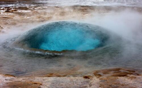
Friday August 24 :
I leave the geothermal area to reach the National Park Thingvellir. A mother and her son drive me there. They are Israelis and return to New York. They enjoy a 4-day stopover to quickly visit Iceland. They offer me a cereal bar and three apples. What a generosity! Hitchhiking allows me to meet lots of friendly people unlike the tourist bus where no one speaks ... Thingvellir is a n important place in the Icelandic history. This is from the 930 years that held "the Alping" first democratic parliament established by the early settlers. Important decisions (laws, court decisions, marriage contracts) were taken at this palce. The site is located at the edge of the North American and Eurasian plates and has many flaws. The settlers chose this place because it is at the crossroads of many paths and close to a lake full of fish: the Pingvallavatn Lake, the largest lake in Iceland with an area of 86 km2. I pick some wild blueberries. The rain began to fall still. My shoes are not at all waterproof. I pitch my tent tonight in the national park Thingvellir.Saturday August 25 :
A family of Vestmannaeyjar islands lgive me a ride until the farm Laxnes. I want to discover the spacific allure of the Icelandic horse. Icelandic horses are small (1.30 m at the withers) but bright and sweet. They look proud and are very well adapted to their harsh environment. Robust like the Vikings animals! The Icelandic horse has five gaits freight (not), the brokk (trot), the stökk (gallop), the Skeid (amble) and tölt (side amble). The breed is still very pure because there was no other imported horses. If an Icelandic horse leaves Iceland he can t go back. Icelandic horses are used for gathering sheep which takes place in autumn. This is the rettur. I do a ride and go to the Vestmannaeyjar islands by ferry from Landeyjahöfn. 
Sunday August 26 - Monday August 27 :
I go around the island in Vestmannaeyjar with Maite met on the evening of my arrival at Heimaey. We ascend the Eldfell that appeared after the volcanic eruption of 1973, which had buried 400 houses and forced the evacuation of the islanders. In the south of the island, I discover the puffin burrows. They are hundred to take off from the cliffs of Fjosin. We see in the distance the island of Surtsey. It appeared in 1963 after an underwater eruption that lasted four and a half years. The island of 2.7 km2 is now 1.4 km2 due to severe erosion with the wind. This island serves as an observatory for scientists. They can see how the plants and animals settled there. It is forbidden to go there. We see a seal. The wind blows and sometimes I have trouble walking. We have a drink in a cafe in the center of Heimaey. I also want to taste the "Pilsner" beer without alcohol. Then I go to the restaurant to eat ... Puffin! Monday is traditionally consumed in Iceland. It has the taste of duck and it's really good! I enjoy the "Egils Malt Extrakt". It is a very sweet non-alcoholic beer. The taste is really strange. For dessert, I eat an Icelandic cheese cake. This 100% Icelandic meal was delicious! The next day, I discover the walls of the old fort Skansinn built in the fifteenth century to protect the islanders from attacks by African pirates. At this point, I saw the remains of a house, water tanks and all power poles destroyed by the lava flow of 1973. I leave Heimaey and Vestmannaeyjar islands by ferry from 14:30. I will have 3 different cars to go to Reykjavík. I meet an industrialist from the Icelandic fishing. He tell me that global warming can be see in the Icelandic water by the coming of new fish (including mackerel) . A Polish-Lithuanian couple installed for 4 years in Iceland tell me that how nice are the small Icelandic towns where everyone knows each other. The last car was the one of a young Icelandic Viking, helicopter pilot, from the Westman Islands.Tuesday August 28 - Wednesday August 29 :
These last two days in Iceland will be devoted to exploring the capital Reykjavik. I shall begin with the street Baebraut along the sea. A cold wind blows strongly. I discovered the famous Sun-Craft sculpture of Jon Gunnar Arnason representing the skeleton of a longship. I join a free guided tour of the city center all in English! Sporting shoulder-length hair and a beard, the guide looks like a Viking like many other men in Reykjavik. Iceland is a safe country with a very low crime rate. Icelanders have no army and the police is very discreet. The gardens of Parliament Alpingi are not kept. Then I continue my tour of the city by the vast Hallgrimskirkja church. Constructed of concrete, it is very modern. It presents both sides of the columns smaller and smaller that are supposed to represent the many basalt in Iceland. The interior is very bare. I enjoyed the "Kanilsnudar" based cinnamon. I take this day to buy some souvenirs including an Icelandic sweater worn by many Icelanders. They are hand-knitted from wool. Wednesday, August 29, the final day of the Icelandic soil. I visit the Botanical Gardens, the National Gallery of Iceland and the Museum of Photography. I wander the streets and sit in the heart of Reykjavik in a place covered with tags where a music group is playing while others are skating. At 6pm I enter a second hand bookstore where I bought a book in Icelandic. Then I go to the bus station where I joined the airport. 0:55am in the plane! I see away the land of fire and ice which I have worn my shoes for nearly one month and half . End of a travel and the beginning of another. From Iceland to New Zealand there is only one step!
 2 commentaires
-
Par Across the land le 24 Juillet 2013 à 21:45

-
Discipline : sport-tourisme
-
Parution : 24-07-2013
-
Auteur : Mélanie Delpont
-
ISBN : 978-2-312-01258-2
-
Format : 120x190 mm
-
Nombre de pages : 102
- Langue : français
-
Série / Collection : Les Editions du Net
- Prix version papier : 14,00€
- Prix version pdf : 8,00€


Voyage en terre de feu et de glace
Mélanie DelpontResumé
Mélanie Delpont a entrepris une traversée à pied en solitaire et en autonomie complète de l'Islande du nord au sud ! De la Mer du Groenland à l'Océan Atlantique, des champs de lave aux rivières glacières, sa marche l'a conduite au cœur d'un pays rude et fragile sur près de 500 km. A travers son regard, ses réflexions et ses rencontres, elle vous emmène à la découverte de cette île à la frontière du cercle polaire arctique et qui sait, vous aurez peut-être, à votre tour, envie d'y aller !
5 commentaires
-
-
-
Par Across the land le 6 Juin 2013 à 15:10

 Signification des lettres utilisées O = oui N = non
 Télécharger « étapes et nuits.pdf »
Download « stages and nights.pdf » 1 commentaire Suivre le flux RSS des articles de cette rubrique Suivre le flux RSS des commentaires de cette rubrique
Beyond the mountains, forests and rivers...
-
Aidez les malades et leur famille, soutenez la recherche contre les maladies du sang!


